


“The weather is very pleasant if overcast, and we are headed for the coast through the forest to have a swim. We reckon that it would take us just over an hour of steady walking to get to the seaside. The hour goes by and no sign of the sandy beach. The conversation does not touch upon the fact that we appear to be going in a wide circle as we start to recognise some of the intersections we have met before. Even the birds seem to have gone quiet. A heavy silence prevails. A different route is tried with the same outcome: basically, we are lost.“
This first short chapter gives an overview of the situation of France in Europe and of some of its geographical features. More detailed descriptions are given in later chapters about some of its regions, its history, and other aspects of the culture of France. Anecdotes are incorporated in each chapter, and these are in italics in the text.
What to Drink While Reading this Chapter
A small glass of Jurançon Blanc.
Jurançon is a wine region near Pau, in the south west of France, at the foot of the Pyrenees. The vines grow on steep slopes. There are dry and sweet white wines, but the sweet wine is more in demand.
Chapter 1
Geography in its simplest form
There were periods in the Middle Ages, from the 10th century onwards, during which penitents from the northern regions of Europe would seek to find redemption for their sins by travelling to Santiago de Compostela in Spain (not in Moors hands), and there, prostrate themselves before “the remains” of James the apostle. As they reached the borders of what is now modern Northern France, they were unaware of the distances and the difficulties facing them. As the crow flies, which is seldomly straight from A to B, there are 1200 kilometres between Flanders and the Western tip of the Pyrenees. Unfortunately, the pilgrims did not have maps and the paths marked by the famous white scallop shell shapes were not always easily found or simply obvious for them to follow. Along the route many died: either of exhaustion after losing their way, or as a consequence of being attacked and despoiled by man or beast. The records of several churches show that some tried to undertake the trip on their knees. It could take as long as 8 months to go from Rocroi in the Ardennes to Saint Jean de Luz on the Spanish border. Others, the richer ones, would pay professional pilgrims to undertake the journey on their behalf. (1)
By Western European standards, France is a large country. The distance from Brest, the most western city in Brittany to Strasbourg, on the left bank of the Rhein River in the east, is approximately 1000kms. A similar number applies to the gap which exists between Dunkirk and Nice on the Mediterranean. In terms of surface area, it is about 550 000 km2, which is twice that of the United Kingdom and Northern Ireland with a very similar population (65 million). The country is often referred to by the French as the Hexagone as it is roughly of that shape.
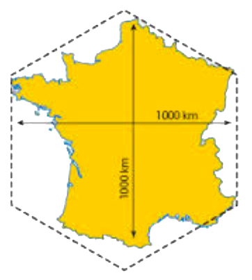
Nowadays, it is surrounded by the United Kingdom (32 km away) directly north across the Channel (La Manche), Belgium (620 km of border with France) in the Northeast, Luxembourg (73km), Germany (451km) and Switzerland (572km) to the East, Italy (515 km) to the Southeast. The Pyrenees in the South divide France from Spain (623 km). Monaco (5.5km) and Andorra (53km) also share a border with the Hexagone. Looking at the map it is easy to think that the border between France and Spain is much longer than any other. Yet it is only 3 km more than that with Belgium.
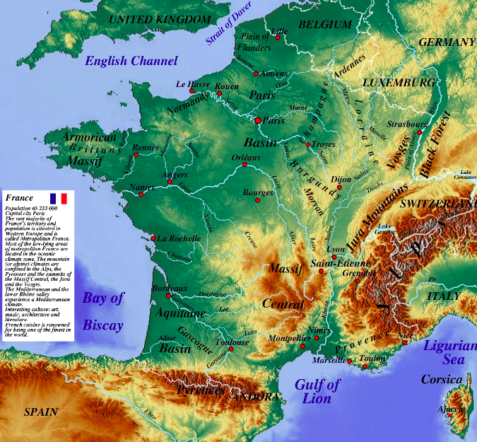
The present shape of the country is quite recent as France lost Alsace-Lorraine to the Germans in 1870, regained it in 1919, then lost the province again in 1940. France is a maritime nation with direct access to the North Sea, the Channel, The North Atlantic and the Mediterranean. Mountain ranges dominate some of the landscapes: the creation of the Vosges, Jura, Alps and Pyrenees is the result of the movements of tectonic plates and are used by tourists for sports during the winter season. The Mont Blanc which has grown by 3 centimetres since the 1950s is still the highest mountain in Western Europe (4810 metres).
Like all its neighbours, the majority of its populations lives in towns and cities. Villages were left dying in the last century as young people moved away from the country to find better living conditions and employment in urban areas. Recent trends seem to indicate that more and more urbanites are leaving their suburbs to renew with life in the campagne. Numerous towns and cities are over 1000 years old and sprang to life during what is called Le Mouvement Communal(2)(3) in the later years of the Frankish Kingdom
and despite early setbacks in its conflict with the religious authorities, it continues to be an important aspect of the political life of the nation.
Nearly one third of France-31%- is covered in forests (as opposed to the UK where it is only 11%). The forests are either protected by law – if they are in the Domaine National or Regional- and industrially exploited if they are in private hands. Napoleon 1st, to make up for all his other short comings if that is possible, ordered the plantation of millions of trees in the Landes region in the Southwest as the sand was starting to move further and further inland (4).
In the 1970s, a friend of mine and I were taking a walk in a forest just south of Boulogne sur Mer in Northern France. My friend is from the region and has set foot on most of the footpaths of the area. The weather is very pleasant if overcast, and we are headed for the coast through the forest to have a swim. We reckon that it would take us just over an hour of steady walking to get to the seaside. The hour goes by and no sign of the sandy beach. The conversation does not touch upon the fact that we appear to be going in a wide circle as we start to recognise some of the intersections we have met before. Even the birds seem to have gone quiet. A heavy silence prevails. A different route is tried with the same outcome: basically, we are lost. This has never happened before to either of us. From a friendly environment, the forest suddenly becomes dark and oppressive as we start to worry. Instinct tells me, irrationally, to start running in one direction and by doing so I will come out of the woods. At the same time, I begin doubting the reassuring noises my friend is making and become more and more angry at the situation we are facing. It is by chance that we come to the foot of a sand dune. We climb it and are glad to see that the tide is high and the sea peaceful. We are much further south than expected but at least my friend knows where we are. It is not difficult to imagine pilgrims experiencing similar circumstances in a country which, in the Middle Ages, was at least 70% covered in forests.
Whilst most counties in the United Kingdom are named after their principal towns – Yorkshire, Gloucestershire, Cheshire etc…, France has used its rivers to name its administrative entities. Paris is in the Seine Département, Nantes in the Loire- Atlantique and Bordeaux in the Gironde to take but a few examples. Throughout its history, rivers have played an important role in the development of France both politically and economically as it has enabled defenders to slow down the numerous armies which came West, and it has helped in the movement and distribution of goods and foodstuffs.
As can be seen from the map, aggressors who came from any direction but East going West, were blocked by the mountains in the Southeast and had to find a way over or around rivers such as the Somme, the Marne or the Seine before reaching the heartland of the nation. The plains which lay in between these northern rivers were and are extremely fertile and serve (d) as the breadbasket of the country.
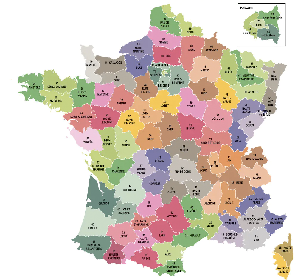
Map of Départements of France. The following are rivers: Seine, Eure, Loire, Loir, Loiret, Meurthe, Meuse, Moselle, Rhin, Yonne,
Oise, Cher, Indre, Allier, Vienne, Rhône, Drome, Var, Aude, Tarn, Garonne, Gironde, Dordogne, Lot
From the late 11th century, cities have played an ever-increasing role in the expansion of France. The gathering of several trades in the same space meant that economic development could take place, especially if the town/city was a marketplace which welcomed traders from outside its boundaries. As soon as there was a market, bankers would open their doors to offer safer handling of payments, walls were built to protect the community and the town became known as an attractive and more secure area for both buyer and seller. Local wealth also meant that places of worship emerged which could become centres for pilgrims to go and spend their money. Guerres de clocher developed as a result of the competitiveness of some of the burghers and/or clergy to use the height of bell towers as a means of gaining an advantage over their neighbours. This was especially the case in the flat plains of Northern and Western France where it was easy to compare the height of one’s clocher to neighbouring churches over the horizon. The competitiveness was exacerbated in the 19th century when the anti-clerical
movement (les Laïcs) started to build Beffrois, complete with bells, as close as possible to the church to show that non-religious people could also have their say in the race. Many of the Beffrois in Flanders and the Somme were destroyed by one side or the other during the First World War as they served as perfect positions for snipers.
As will be described in the history chapter, the development of towns and cities occurred at times of increasing industrial/commercial activity. From the late 18th century onwards the fact that Northern France had more raw materials than the South meant that cities north of the Loire developed faster than those along the Mediterranean Coast.
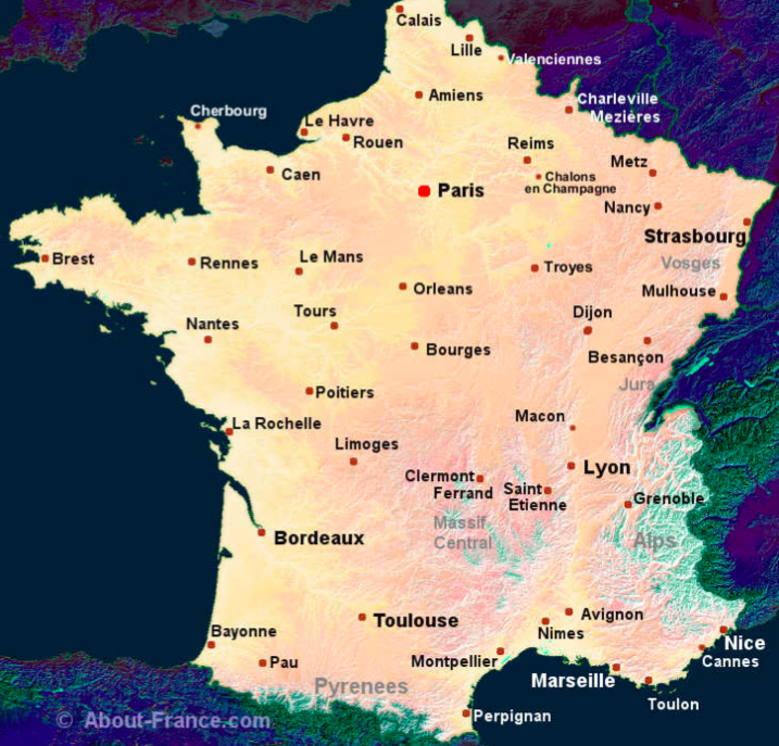
The top 10 cities in terms of population are:
- Paris: 12 405 000 (this is for the Grand Paris. The city itself has only 2.5 million people living in it)
- Lyon: 2 237 000 (Lyon has only recently become the second city)
- Marseille: 1 734 000 (Marseille is losing its popularity as it is seen as being violent)
- Toulouse 1 291 000 (Toulouse is the centre of the technological industry)
- Bordeaux 1 178 000 (Wine, wine and more wine)
- Lille 1 175 000 (Centre of European affairs)
- Nice 1 004 000 (One of the most visited by tourists after Paris)
- Nantes 908 00 (Made its fortune in the Triangular Trade)
- Strasbourg 773 000 (Relies on its German neighbour for most of its wealth)
- Rennes 700 000 (Late forays into the technological world seem to be working)
Lately the country has been divided into much larger administrative entities, headed by a Super Préfet whose seat of power is in the largest city of the region.

Paris has been the capital of France for over one thousand years. The history chapter will show that the country it has administered has not always been the size of the Hexagone as we know it today. Far from it! It was, up to the start of the pandemic, the most visited city in France. Compared to other capitals, it is rather small: about 105 km2 (Berlin is 8 times lager at 892 km2) with a population of 2.2 million people and 1 million cars. Surprisingly for a Catholic country only 33% of the inhabitants of the city are married. Sadly, 12% of the Parisiens are unemployed. Young people and women are more likely to be without work than any of the other sections of society. The pandemic has accelerated the process as tourists and businesspeople are not flying in to spend their money in the capital. (5)
Before looking at the history of France in some detail, readers have the opportunity to take part in a little quiz about this first section.
Chapter One (pdf) or Chapter One (Word download).
Quiz
Try out the Geography Quiz.